Information Report No. 06-15
Draft Plans of Subdivision Applications SP-2015-01, SP 2015-03, SP-2015-04; SP-2015~05, SP-2015-06
Zoning By-law Amendment Applications A 2/15, A 5/15, A 8/15, A 10/15 and A 11/15
Ontario Infrastructure and Land Corporation Seaton Community

Download Report
Ontario Infrastructure and Land Corporation (OILC) has submitted five applications for the approval of draft plans of subdivision and related zoning by-law amendments. The proposals reflect the developable OILC lands in each of the Seaton Neighbourhoods. Further, all the Seaton Natural Heritage System lands throughout Seaton are included in one of the rezoning applications.
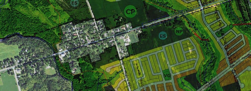
Of particular interest to Whitevale is the following application that includes the Gravel Pits, lands around the Whitevale Cemetery, and lands north and south of Whitevale Road at the east end of the village (see map above) :
Draft Plan of Subdivision SP-2015-06 and Zoning By-law Amendment A 11/15 Neighbourhoods 18 and 16
These applications represent the remnant developable parcels owned by OILC in Seaton Neighbourhood 18, Mount Pleasant and two small parcels in Neighbourhood 16, Lamoreaux (see Neighbourhood 18: Mount Pleasant Neighbourhood Plan, Attachment #18 and Neighbourhood 16: Lamoreaux Neighbourhood Plan, Attachment #19). The subject draft plan represents the OILC developable lands within these Neighbourhoods. The majority of developable lands in these Neighbourhoods are owned by various Seaton developers that have been rezoned and the subdivisions have been draft approved.
Property Description
• the subject lands consisting of eight individual parcels spread across Neighbourhood 18, as well as two parcels in Neighbourhood 16
• some of these parcels of land are small remnant pieces and others are larger developable blocks (see Location Map, Attachment #20)
• the subject lands have a total area of approximately 41 hectares
• the Provincially owned lands in Neighbourhood 18 are spread across the northern portion of Neighbourhood 18, and are generally adjacent to Low Density Type 1 land uses that are held by other landowners and are also adjacent to the Seaton Natural Heritage System and/or the Hamlet of Whitevale
• the subject lands include lands designated as Low Density Area Type 1, Low Density Area Type 2, Village Green, Open Space and Hamlet Heritage Open Space
• a Community Park, a Neighbourhood Park and two elementary schools sites are identified within the lands designated Hamlet Heritage Open Space
• the Neighbourhood 16 lands include a block designated as a Mixed Corridor Type 2- Gateway Site, and a block for High Density Residential
Application Detail
• the proposed draft plan of subdivision is reflective of the land use designations in Neighbourhoods 16 and 18 of the Official Plan (see Submitted Plan, Attachment #21)
• the larger development blocks in Neighbourhood 18 are adjacent to the Hamlet of Whitevale
• the lands that partially surround the Hamlet of Whitevale, located in the lands designated Hamlet Heritage Open Space, are intended to provide a buffer/transition between new urban development and the Hamlet, while supporting community integration
• the Hamlet Heritage Open Space designation allows for institutional and recreational facilities, including two blocks for elementary schools, a Community Park, a Neighbourhood Park and a stormwater management pond
• two blocks for elementary school sites are located in the northwestern and southeastern corners of the Hamlet Heritage Open Space
• the Hamlet Heritage Open Space designation also has a Neighbourhood Park proposed south of Whitevale Road, and a Community Park north of Whitevale Road; both parks are directly adjacent to new Low Density Area neighbourhoods
• north of the Hamlet Heritage Open Space designation, on the west side of North Road, is a residential development parcel that is proposed for 148 detached dwellings and 24 semi-detached dwellings
• the other developable parcel in Neighbourhood 18 is on the south side of Whitevale Road, east of the Whitevale Cemetery
• this parcel is proposed for 4 7 detached dwellings
• an open space block is proposed on the west side of the cemetery that is designated as Cemetery
• the two remnant developable parcels in Neighbourhood 16 are a Gateway block along Sideline 26 that is anticipated to be developed with adjacent property, and a High Density block along Taunton Road
• see Draft Plan of Subdivision SP-2015-06 details on Attachment #22